Figura:India (orthographic projection).svg
Archivi original(archivi an forma SVG, amzure nominaj 541 × 541 pontin, amzura dl'archivi: 280 KByte)

Cost archivi a riva da Wikimedia Commons e a peul esse dovrà da dj'àutri proget. La descrission an soa pàgina ëd dëscrission ëd l'archivi a l'é smonùa sì-sota.

Oget

Descrission
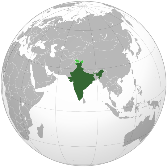
English: India. Area controlled by India in dark green; claimed but not controlled areas in light green.
Data
Sorgiss

Own work,

 
Questa grafica vettoriale è stata creata con Inkscape .

Aquarius.geomar.de

বাংলা  English  español  français  italiano  日本語  македонски  sicilianu  中文(简体)  中文(繁體)  +/−

GNU head A l'é dàit ël përmess ëd copié, distribuì e/o modifiché sto document-sì sota ij term ëd la GNU Licensa ëd Documentassion Lìbera, Version 1.2 o minca version publicà apress da la Fondassion për ij Programa Lìber; sensa gnun-e Session Anvariante, gnun Test ëd Cuvertin-a, e gnun Test ëd retro-Cuvertin-a. Na còpia dla licensa a l'é ancludùa ant la session antitolà GNU Licensa ëd Documentassion Lìbera.
Autor Ssolbergj (talk)
Àutre version

Opere derivate da questo file:

This is a Grey & green orthographic projection map.
العربية: الرجاء، قراءة الميثاق.
বাংলা: দয়া করে, রীতিনীতিটি পড়ুন
Deutsch: Bitte lies die Konventionen.
English: Please, read the conventions.
Español: Por favor, lea las convenciones.
Filipino: Paki-basa ang mga kumbensyon.
Français : S'il vous plaît, lisez les conventions.
हिन्दी: कृपया सभागमों को पढ़ लें.
Bahasa Indonesia: Silakan, baca konvensi.
Italiano: Si prega di leggere le convenzioni.
ქართული: გთხოვთ, გაეცნოთ კონვენციებს.
Português: Por favor, leia as convenções.
Русский: Пожалуйста, прочитайте соглашения.
Українська: Будь ласка, прочитайте конвенції.
Tiếng Việt: Hãy đọc công văn trước khi đăng.
World maps

Africa

हिन्दी: अफ्रीका
ქართული: აფრიკა.

Eastern Africa

Southern Africa

Central Africa

Northern Africa

Western Africa

Americas

ქართული: ამერიკა.
हिन्दी: अमेरिका

North America

Central America

Caribbean

South America

Asia

ქართული: აზია.
Português: Ásia.
Українська: Азія.

East

Português: Ásia Oriental.
Українська: Східна Азія.

Central

हिन्दी: मध्य एशिया
Português: Ásia Central.
Українська: Центральна Азія.

Southeast

Bahasa Indonesia: Asia tenggara
Português: Sudeste Asiático.

South

(भारतीय उपमहाद्वीप)
Português: Sul da Ásia.
Українська: Південна Азія.

Western

Português: Sudoeste da Ásia.
Українська: Передня Азія.

Europe

हिन्दी: यूरोप
ქართული: ევროპა.
Português: Europa.
Română: Europa.
Русский: Европа.
Українська: Європа.

Countries

Oceania

हिन्दी: ओशिआनिया
ქართული: ოკეანეთი.
Português: Oceania.
Українська: Океанія.

Intercontinental

Português: Intercontinental.
Українська: Міжконтинентальні.

Historical

English: Unions, Organizations, Kingdoms, Empires
Español: Uniones, Organizaciones, Reinos, Imperios
Filipino: Mga Unyon, Organisasyon, Kaharian, Imperyo
Français : Unions, Organisations, Royaumes, Empires
हिन्दी: संघ, संगठन, राज्य, साम्राज्य व ऐतिहासिक देश
ქართული: გაერთიანებები, ორგანიზაციები, სამეფოები, იმპერიები
Português: Estados extintos.
Tagalog: Mga Unyon, Organisasyon, Kaharian, Imperyo
Українська: Союзи, Організації, Королівства, Імперії

Subnationals

हिन्दी: उपराष्ट्रीय इकाईयाँ
Orthographic projections maps created by Ssolbergj
Orthographic projections maps created by Ssolbergj:

Licensa

Mi, ël padron dij drit d'autor dë sto travaj-sì, i lo pùblico ambelessì sota ste license-sì:
GNU head A l'é dàit ël përmess ëd copié, distribuì e/o modifiché sto document-sì sota ij term ëd la GNU Licensa ëd Documentassion Lìbera, Version 1.2 o minca version publicà apress da la Fondassion për ij Programa Lìber; sensa gnun-e Session Anvariante, gnun Test ëd Cuvertin-a, e gnun Test ëd retro-Cuvertin-a. Na còpia dla licensa a l'é ancludùa ant la session antitolà GNU Licensa ëd Documentassion Lìbera.
w:pms:Creative Commons
atribussion partagi ugual
Chiel a l'é lìber:
  • ëd partagé – ëd copié, distribuì e fé giré cost travaj
  • ëd riorganisé – d'adaté ël travaj
Sota le condission sì-dapress:
  • atribussion – A dev dé ij credit aproprià, dé n'anliura a la licensa e indiché s'a son ëstàit fàit dij cambiament. A peul fé sòn an qualsëssìa manera rasonèivola, ma pa an na fasson ch'a sugerissa che l'autor a apreuva chiel o sò usage.
  • partagi ugual – Se chiel a modìfica, a cangia, o as basa ansima a 's travaj, a deuv distribuì soe contribussion sota l'istessa licensa o a na licensa compatìbil con l'original.
It peule selessioné la licensa ch'it veule.
{{{template}}} Warning! According to Indian law, it is illegal to produce maps that in the view of the Indian government, misrepresent Indian territories by showing areas the Indian government claims ownership of but does not control as not belonging to India or as being contested.

Didascalie

Aggiungi una brevissima spiegazione di ciò che questo file rappresenta
india

Elementi ritratti in questo file

raffigura italiano

creatore italiano

Valore sconosciuto senza un elemento Wikidata

novèmber 2008

tipo di file italiano

image/svg+xml

Stòria dl'archivi

Ch'a-i daga un colp col rat ant sna cobia data/ora për ës-ciairé coma a restèissa l'archivi ant col moment-là.

(Ùltima | Prima) Che a varda (10 pì neuv) () (10 | 20 | 50 | 100 | 250 | 500).
Data e OraMiniaduraAmzureUtentComent
dël dì d'ancheuj09:10, 26 Avr 2023Miniadura dla version ëd 09:10, 26 Avr 2023541 × 541 (280 KByte)Swtadi143Reverted to version as of 07:34, 16 September 2021 (UTC) siachen glacier is fully controlled by india and not india pakistan jointly, see Siachen conflict for context.
12:02, 20 Stè 2021Miniadura dla version ëd 12:02, 20 Stè 2021512 × 512 (155 KByte)Ytpks896Reverted to version as of 17:38, 6 September 2021 (UTC) Siachen is a disputed territory not fully controlled by single country it is controlled by both Pakistan and india & some parts by china
09:34, 16 Stè 2021Miniadura dla version ëd 09:34, 16 Stè 2021541 × 541 (280 KByte)Ksh.andronexusReverted to version as of 16:08, 19 December 2019 (UTC)
19:38, 6 Stè 2021Miniadura dla version ëd 19:38, 6 Stè 2021512 × 512 (155 KByte)MilenioscuroSiachen is a disputed territory between China, India and Pakistan
18:08, 19 Dze 2019Miniadura dla version ëd 18:08, 19 Dze 2019541 × 541 (280 KByte)Goran tek-enAdded border for South Sudan as requested by {{u|Maphobbyist}}
16:04, 21 Otó 2017Miniadura dla version ëd 16:04, 21 Otó 2017541 × 541 (139 KByte)Goran tek-enAdded Siachen Glacier as requested by {{u|King Prithviraj II}}
23:31, 12 Stè 2012Miniadura dla version ëd 23:31, 12 Stè 2012541 × 541 (167 KByte)PalosirkkaScrubbed with http://codedread.com/scour/
01:40, 16 nov 2009Miniadura dla version ëd 01:40, 16 nov 2009541 × 541 (573 KByte)Shibo77+Eritrea, Yemen; -neutral zone
15:18, 1 nov 2009Miniadura dla version ëd 15:18, 1 nov 2009541 × 541 (496 KByte)Pahari SahibMap showing territory governered by India, see map of Pakistan
15:17, 11 mar 2009Miniadura dla version ëd 15:17, 11 mar 2009541 × 541 (572 KByte)TryphonReverted to version as of 22:12, 13 February 2009: please use the talk page before reverting this image; there are apparently many people who want the map this way.
(Ùltima | Prima) Che a varda (10 pì neuv) () (10 | 20 | 50 | 100 | 250 | 500).

Le pàgine sì-sota a l'han andrinta dj'anliure a sta figura-sì:

Dovragi global dël file

J'àutre wiki sì sota a deuvro st'archivi-sì:

Varda l'usagi global dë st'archivi-sì.

Dat adissionaj